Tropical Depression Nine is expected to strengthen into Tropical Storm Imelda by Sunday evening as it approaches the Southeast U.S. coast, prompting South Carolina and North Carolina governors to declare states of emergency ahead of potentially devastating impacts. The storm, currently located 100 miles west-southwest of the Central Bahamas with 35 mph winds, could reach Category 1 hurricane status by late Monday or Tuesday as it threatens coastal areas from Florida to Virginia with heavy rainfall, storm surge, and damaging winds.
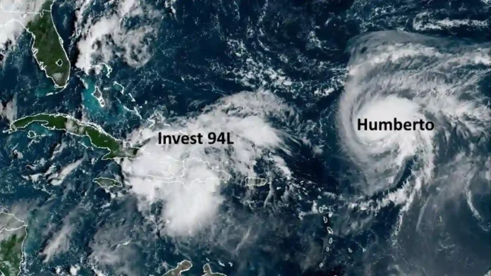
Satellite image showing tropical storm Invest 94L and hurricane Humberto in the Atlantic basin near the Caribbean, captured by GOES-19 satellite
The National Hurricane Center warns that the most concerning scenario involves the storm stalling just offshore the Carolinas for multiple days, potentially dumping up to 18 inches of rain in some areas and creating life-threatening flooding conditions across a region still recovering from previous hurricane impacts.
Read Also: Penn State Football Faces Harsh Reality After Stunning White Out Loss to Oregon
Current Storm Status and Forecast Track
System Strengthens Over Warm Waters
As of Sunday morning, Tropical Depression Nine was moving northwest at 7 mph through the Bahamas, where tropical storm warnings remain in effect. The system is expected to encounter more favorable atmospheric conditions over the Gulf Stream’s warm waters, fueling rapid intensification as it approaches the U.S. mainland.
Meteorologists predict three potential scenarios for the storm’s path: turning east and remaining offshore (most likely), stalling near the coast for several days, or making direct landfall along the Georgia or Carolina coasts. The storm’s ultimate behavior will be significantly influenced by the position of Category 4 Hurricane Humberto, which is churning in the Atlantic several hundred miles to the east.

Complex Atmospheric Interactions
The forecast complexity stems from potential interactions between Imelda and Hurricane Humberto, which rapidly intensified to Category 4 status with 145 mph winds. Scientists are monitoring a possible Fujiwhara effect, where two cyclones begin rotating around a common center, which could dramatically alter both storms’ paths.
“There is a strong consensus in the various computer forecasts that Imelda will likely track to the north, paralleling the Florida coast at least through the weekend,” explained Bryan Norcross, FOX Weather Hurricane Specialist. “About Monday, however, it looks likely to face a fork in the road. Either it will turn right, out to sea, or it will arc left into the Georgia, South Carolina, or North Carolina coast”.
Read Also: Green Man Festival 2025 Tickets Go On Sale This Saturday
Emergency Preparations Accelerate Across Region
Multi-State Response Mobilizes
South Carolina Governor Henry McMaster declared a statewide emergency Friday, emphasizing the storm’s serious threat despite forecast uncertainties. “This storm is deadly serious. Not just serious. Deadly serious,” McMaster stated during a Saturday press conference, warning residents about potential high winds and flooding.
The emergency declaration allows the state to mobilize search and rescue teams, pre-position equipment including helicopters and aerial resources, and coordinate with federal authorities for potential disaster response. McMaster indicated no plans for mandatory evacuations but urged residents to monitor conditions closely.
Local Communities Take Precautionary Measures
Charleston has deployed stormwater pumps and lowered local lake levels as precautionary measures, while the city declared a local state of emergency Saturday. Conway, South Carolina, and Folly Beach have also implemented emergency protocols, with Folly Beach closing City Hall Friday in preparation.
North Carolina Governor Josh Stein declared a state of emergency Sunday morning, activating the state’s emergency management resources. The coordinated regional response reflects lessons learned from previous devastating storms, particularly Hurricane Helene’s impacts one year ago.
Read Also: Miami Becomes the ACC Only Hope for a National Title in 2025
Expected Impacts and Threats
Rainfall Flooding Primary Concern
The National Hurricane Center identifies heavy rainfall as the storm’s most dangerous threat, with forecasts calling for 4-8 inches across the region and up to 18 inches in the heaviest-hit areas. The slow-moving nature of the system could create prolonged rainfall events, overwhelming rivers, streams, and drainage systems already saturated from recent weather.
“Moisture from the disturbance will lead to a threat of heavy rainfall well to the north across portions of the Southeast U.S. and Virginia into early next week which could cause flash, urban, and river flooding,” warns the National Hurricane Center.
Coastal and Storm Surge Threats
Even if Imelda remains offshore, dangerous storm surge of 1-4 feet is forecast along the coast from Georgia to North Carolina. Days of onshore winds will generate life-threatening rip currents and dangerous surf conditions up and down the Eastern Seaboard, with both Imelda and Hurricane Humberto contributing to hazardous ocean conditions.

Tropical storm-force winds of 39-73 mph are possible along the immediate coastline, with the strongest impacts expected if the storm’s core approaches land. The combination of storm surge, heavy rainfall, and sustained winds poses significant flooding risks for low-lying coastal communities.
Read Also: How to Watch BTS Live: Complete 2025 Guide for Every ARMY Fan
Bahamas Face Immediate Impact
The Bahamas are currently experiencing the storm’s initial effects, with tropical storm warnings in effect for the central and northwestern islands. Heavy rainfall totals of 4-8 inches are forecast, with storm surge of 1-3 feet above normal tide levels creating dangerous conditions for island communities.
Scientific Analysis and Forecast Challenges
Hurricane Hunter Data Collection
NOAA’s Hurricane Hunter aircraft have conducted multiple reconnaissance missions into the developing system, providing crucial atmospheric data to improve forecast accuracy. The flights collect upper and lower-level atmospheric measurements that help computer models better predict the storm’s track and intensity.
The storm’s current lack of a well-defined center contributes to forecast uncertainty, though meteorologists expect more reliable tracking once the system becomes better organized. Weather balloons are being launched at increased frequency to gather additional atmospheric data.
Read Also: Best Budget Smartphones with Amazing Features to Buy This Year
Model Consensus and Variations
While forecast models show increasing agreement about the storm remaining offshore, significant uncertainty remains about its exact path and potential for stalling near the coast. The interaction with Hurricane Humberto adds another variable that could dramatically influence Imelda’s behavior.
Computer models suggest the storm will slow dramatically as it approaches the Southeast coast Tuesday, with some scenarios showing it remaining nearly stationary for 24-48 hours. This potential stalling pattern creates the highest risk for catastrophic flooding impacts.
What Comes Next
Monday-Tuesday Critical Period
The storm is expected to reach tropical storm intensity by Sunday evening and potentially strengthen to a Category 1 hurricane by Monday night or Tuesday morning as it approaches the Southeast coast. The Tuesday-Wednesday timeframe represents the period of greatest threat for the Carolinas and coastal Georgia.
Residents from Florida to Virginia should finalize preparations by Monday morning, as conditions are expected to deteriorate rapidly thereafter. The National Hurricane Center emphasizes that dangerous impacts are likely even if the storm remains offshore.
Long-term Implications
Should Imelda stall offshore as predicted, the resulting flooding could rival some of the Southeast’s most devastating rain events. Areas still recovering from previous hurricanes face particular vulnerability, with saturated soils unable to absorb additional heavy rainfall.
The storm’s behavior will provide valuable data for future hurricane forecast, particularly regarding storm interactions and stalling patterns near the coast. Emergency management officials are using this event to test regional coordination systems ahead of the peak hurricane season period.
Frequently Asked Questions
When will Tropical Storm Imelda make its closest approach to the U.S. coast?
The storm is forecast to reach its closest approach to the Southeast coast Tuesday and Wednesday, potentially stalling just offshore for 1-2 days before turning east toward the Atlantic.
Which areas face the greatest threat from the storm?
Coastal areas from northern Florida to southern Virginia are under threat, with the Carolinas facing the highest risk of significant impacts from heavy rain, storm surge, and tropical storm-force winds.
How much rainfall is expected from Tropical Storm Imelda?
Widespread rainfall of 4-8 inches is forecast across the region, with isolated areas potentially receiving up to 18 inches, creating dangerous flash flood and river flooding conditions.
Could Hurricane Humberto affect Tropical Storm Imelda’s path?
Yes, Hurricane Humberto’s position and strength could influence Imelda’s track through a potential Fujiwhara effect, possibly helping to pull the storm away from the coast or affecting its stalling behavior.


